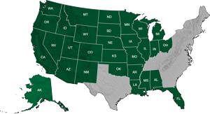
Public Land Survey System Land Grid Data
Our Public Land Survey is a seamless, high-resolution database of Congressional Survey townships and sections that is ideal for base maps and plotting land ownership and leases. Public Land Survey is offered as either USGS PLSS digitized from USGS 1:24,000 series topographic maps, or BLM CAD NSDI PLSS land grid format. For the USGS derived product, DDS used a highly accurate spatial averaging digitizing technique, which captures corner boundaries to +/- 40 foot accuracies. Land grid matches the USGS 1:24,000 scale topo maps pricesly.
Features:
- Ready to use in all GIS and CAD software applications
- Pre-symbolized MXD template is be provided for ArcGIS Desktop and ArcGIS for Server users
- Pre-symbolized styles for AutoCAD and Global Mapper users
- Deploy the data through map servers such as ArcGIS for Server and MapServer
- A unified and consitent dataset across states under the PLS system
PLSSFinder™ is a free application that enables users to download up to 9 townships of BLM-based Public Land Survey grid in an Esri .shp file or File Geodatabase. The user has the ability to search by section, township, and range, download selected areas and/or print maps of the land survey information within a web-based map application. Users also have the option to purchase state or nation-wide bundles of our seamless Public Land Survey grid for use in ArcGIS, Petra, Geographix, or AutoCAD. For online orders, there is an option to purchase the BLM-based land grid, or the USGS-based land grid. The USGS-based land grid will precisely match the section lines from the 1:24,000 scale USGS topographic maps.


