Land Survey (Cadastral) Data
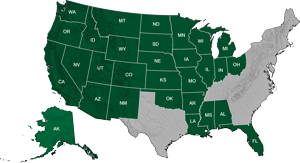
USGS Public Land Survey System Land Grid Data- DDS's Public Land Survey is digitized from USGS 1:24,000 series topographic maps using a highly accurate spatial averaging digitizing technique, which captures corner boundaries to +/- 40 foot accuracies. The Wyoming resurveys are included and Carter townships are used for Kentucky and Tennessee. There is an option to purchase the BLM-based land grid, or the USGS-based land grid. The USGS-based land grid will precisely match the section lines from the 1:24,000 scale USGS topographic maps.
Texas Land Survey Data- DDS is pleased to offer Texas Land Survey datasets. The Texas Land Survey dataset is a seamless, high-resolution database of county boundaries, blocks, surveys, abstracts, subdivisions, lots, and tracts that is ideal for base maps and plotting land ownership and leases.
PLSSFinder™ is a free application that enables users to download up to 9 townships of BLM-based Public Land Survey grid in an Esri .shp file or File Geodatabase. The user has the ability to search by section, township, and range, download selected areas and/or print maps of the land survey information within a web-based map application. Users also have the option to purchase state or nation-wide bundles of our seamless Public Land Survey grid for use in ArcGIS, Petra, Geographix, or AutoCAD. For online orders, there is an option to purchase the BLM-based land grid, or the USGS-based land grid. The USGS-based land grid will precisely match the section lines from the 1:24,000 scale USGS topographic maps.

